Intro to GIS: Final Project – Impact Analysis of Trans Mountain Pipeline Extension: Social and Environmental Assessment of Potential Leak
Our final group project focused on the potential leak impacts on both built infrastructure and natural environment from the Trans Mountain Pipeline Extension Project.
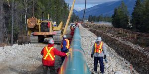
As for the final project, our group has conducted an impact assessment of a potential leak in the Trans Mountain pipeline extension project (through the municipality of Burnaby). We specifically chose this topic as this pipeline extension project has remained a contentious issue and received widespread critics and protests from local Burnaby residents. The project itself is the hotspot for an intense dispute between the extension supporters and opposers in the municipality of Burnaby. As the residents in Burnaby are highly concerned about the public safety and the environmental threats or impacts that the project will pose, and the construction has already started without the approval of the City of Burnaby, our group has focused on the extension impacts on the built infrastructure and natural environment in this area. We have divided our group into two halves, where one member will focus on visualizing the data for the natural environment, and the other two members will work on social (or human) impact data visualization. The Ben Fry’s stages are written separately for environmental and human impact assessments, which include select by attributes (through SQL) and 100-meter buffer of extension pipeline that is common to both, with the addition of intersect and select by location functions for environmental impact assessment and use of field calculator for human impact assessment. Query language, proximity analysis and overlay tools have been used throughout our GIS analysis, which constitutes a significant part of the process of digital data visualization. Around data management on our team, we encountered a significant issue where the dataset of both existing and extended pipelines is not for (public) open access. As a result, we have to draw the pipeline layers by hand, which involves uncertainties and potential errors. Although it was drawn carefully in reference to the visual from the Trans Mountain Website, there is no guarantee that the pipeline is the exact location that it will be in real life. This, in turn, affects analysis that has been based on it, such as the buffers and intersects analysis. Another issue around proprietary data would be accessing the metro Vancouver road data for human impact assessment as it is DMTI CanMap data that needs a license to use, which we obtained through our UBC logins at last. There is also data deficiency on the specific polygons of civic places and population distribution in the city of Burnaby.