Student Club Leader of “International Family Union” (Oct 2019 – Present)
![]()
Student Club Leader of “International Family Union” at UBC (Oct 2019 – Present)
Go Global Ambassador (Sep 2021 – Present)
Go Global Ambassador at Uni of British Columbia (Sep 2021 – Present)
Climate Actions Committee Volunteer (Sep 2021 – Present)
Climate Actions Committee Volunteer (Sep 2021 – Present)
University Neighbourhood Association (UNA) Resident Volunteer (Oct 2021 – Present)
UNA Resident Volunteer in Wesbrook Village, 5923 Berton Avenue, Vancouver, BC (Oct 2021 – Present)
Sessional Researcher (Jun 2019 - Aug 2019)
Sessional Researcher in Key Laboratory of Environmental Health, Shanghai Meteorological Service, Shanghai, China (Jun 2019 - Aug 2019)
Research Assistant/Data Analyst
Research Assistant/Data Analyst in Shanghai Children’s Medical Center, Shanghai, China
Introduction to Systematic Program Design: Male to Female COVID-19 Positive Case Ratio across Different Age Cohorts using Data from BC CDC from First Reported Case to 2021 September
Produced a Graph of Male to Female COVID-19 Positive Case Ratio with Python Coding & Programming
Air Pollution Meteorology: Analysis of COVID-19 Dispersion and Local Meteorology in Toronto
Highlight: Atmospheric HYSPLIT Model Adopted for Analysis
Stats in Geog: Examining PM2.5 Concentration Levels Before and After COVID-19 Restrictions at Vancouver International Airport
Highlight: Spearman's Rank Correlation Coefficient through Coding in RStudio
Research Assistant/Data Analyst (Jun 2020 – Aug 2021)
Research Assistant/Data Analyst in Shanghai Children’s Medical Center, Shanghai, China (Jun 2020 – Aug 2021)
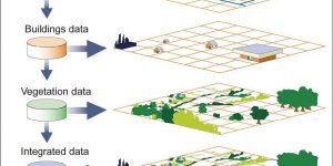
Advanced GIS: Final Project - Multi-Criteria Evaluation (MCE) Analysis of Potential Sites for Solar Panels in Pangasinan, Philippines

It is the final project related to the topic of MCE.
Intro to GIS: Personal Statement
Personal Statement - reflection as a result of learning with GIS Science
2019-20 Arts Imagine Day Orientation Leader

2019-20 Imagine Day Orientation Leader for the faculty of Arts
2019 MURC Volunteer

Volunteering in MURC (Multidisciplinary Undergraduate Research Conference) on March 16th, 2019 – involving morning check-in booth service, oral presentation room setup and presentation timing
UBC CSSA Plogging Volunteer

Participating in UBC CSSA 2018 Plogging held at Queen Elizabeth Park on 2018 November 3rd
Cartography: Final Project
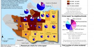
My final project investigates the relationship between individual socio-economic wellbeing (measured by median individual total income) and crime incidents and types in neighbourhoods of the city of Vancouver in 2016.
Intro to GIS: Final Project - Impact Analysis of Trans Mountain Pipeline Extension: Social and Environmental Assessment of Potential Leak
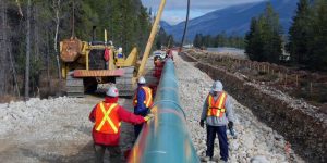
Our final group project focused on the potential leak impacts on both built infrastructure and natural environment from the Trans Mountain Pipeline Extension Project.
Intro to GIS: Environmental Impact Assessment (EIA)
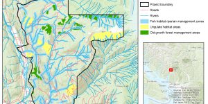
In this assignment, I produced two maps of ecologically sensitive areas (one showing the project area and snow line/high elevation and protected areas and the other showing the same data draped on a 3D Hillshade) from the Proposed Garibaldi at Squamish Ski Hill Project in British Columbia, Canada. I incorporated all the Ben Fry's stages of an effective data visualization to determine areas that must be ecologically protected and undisturbed from the development of the Ski Hill project.
Intro to GIS: Rental Affordability
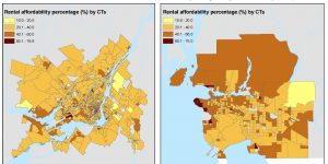
In this assignment, I joined variables in tabular files to spatial maps files for Census Tracts (CTs) in both Metro Vancouver and Montréal. I then visualized and worked with rental housing cost data by exploring various methods for classifying quantitative data (monthly cost of rent) for Metro Vancouver CTs, comparing the monthly costs to Montréal, and also looked at another rental indicator which is housing affordability (the percent of people spending more than 30% of their income on rent).
Intro to GIS: Planning for flooding/Storm Surge
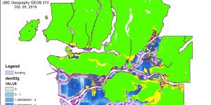
In this assignment, I worked more closely with spatial and tabular datasets, both raster and vector, and was also exposed to a variety of basic GIS Analysis tools, to produce a series of maps that highlight the areas in Metro Vancouver that are at risk to flooding during a storm surge.